We are mapping a heritage ecology of the metropolis of Madrid presented through theories, histories and designs.
No European metropolis can be planned through binary theories that separates city from countryside, culture from nature, past from future. The perspective of ecology has overcome these unproductive divisions and open the territorial design agenda to new questions. Metropolises are now complex urban-rural gradients endowed with multifunctional landscapes with truly hybrid natural-cultural values. These values emerge in the ecological interconnection of environmental, social and economic trends. In this context, we believe that heritage can be a partner for ecologising our territory in a new metropolitan agenda. To look at this opportunity, we are mapping the Metropolitan Region of Madrid, the ensemble of its everyday landscapes, as well as its unique and degraded landscapes. Using large spatial databases and our own fieldwork in three mapping work packages (MWP), critical mapping allows us to represent theories, histories and designs in an interconnected heritage ecology. At the same time, we will expand the discussion with colleagues researching other European metropolises.
MAPPING INFRASTRUCTURES AND NATURECULTURE VALUES
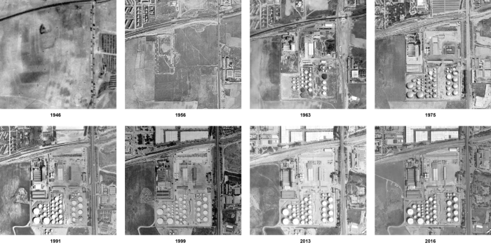
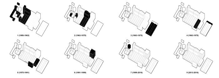
Conceived as territorial supply and regulation networks, metropolitan infrastructures hide histories. Infrastructure is originally planned and designed, but its current form is often the result of aggregations over time – it needs repairs, extensions or partial replacements, and is rarely completely replaced. Infrastructures often leave spatial traces that explain the functions and shape of our landscapes. Therefore, green, blue or transport infrastructures can become a heritage ecology that project the past into the present and the future. We believe that the natural-cultural values of infrastructures can help us to understand the complexity of our metropolitan landscape, as well as to achieve future quality landscapes.
MAPPING CULTURAL ASSETS AND PROTECTED LANDSCAPES
While natural heritage policies often exclude a real attention to cultural features, cultural heritage policies dismiss nature. Both have led to a spatial configuration of protected and seeming isolated patches. But on the one hand, the landscape of natural parks is the result of traditional human use of resources. On the other hand, historic sites had a strong sense of place and became fundamental patches of territorial structuring in an environmental sense. Based on ecological theories of heritage, we believe that protected patches contribute more to the quality of life if we can integrate them into heritage territorial systems. To this end, new imaginaries of conservation must be envisioned.
MAPPING AGROECOLOGY AND SUPPLY CHANNELS
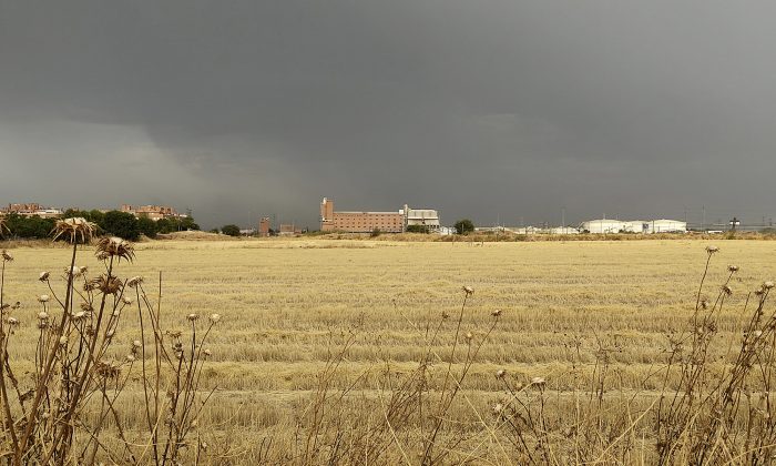
In our metropolitan territory, a concentric urban-rural gradient is crossed by a geographical gradient that goes from the Sierra de Guadarrama in the northwest to the plain of the Tagus River in the southeast. Here, agricultural draws diversified and sometimes rare patterns. Farming intermingles with the villages and modern urbanization further away from the capital, but also tries to penetrate the capital itself. Moreover, agriculture is present in historical places and is sometimes related to our scientific and technological heritage. We understand agriculture as a vector of patrimonialisation and social and environmental innovation, capable of providing new forms of public spaces and landscapes.
Research team:
The success of beer as a mass-consumption product in the city of Madrid was definitively consolidated during the 19th century, thanks to the advances that accompanied the Industrial Revolution in the development of production, pasteurization, refrigeration, and distribution techniques. All of this led to the emergence of significant large-scale industrial production infrastructures which, while facilitating greater accessibility to beer consumption, also contributed to a progressive disconnection between the consumer and its production process; between the consumption of the product and the knowledge of its production, as well as the spaces in which it takes place. Therefore, today, thanks to the emergence of a new aesthetic-ecological paradigm in response to our delicate environmental and urban context, it seems essential to reclaim and, above all, recover that original relationship between the spaces of production and consumption in our cities; with the ultimate goal of preserving and returning to the entire population the knowledge of food and its cycles.
Matrix of historical advertising posters for El Águila beer. It is interesting to note how, initially, the product's advertising implicitly included communications about the spaces and processes of its production.
The former El Águila brewery, built by the architect Manuel García Morales (in collaboration with his son, Manuel García López) between 1960 and 1990 in the southern part of Madrid’s Villaverde district, is one of the many examples of industrial architecture built on the city’s outskirts during the second half of the 20th century. However, it is a particularly unique case due to its isolated location relative to the surrounding urban fabric, the formal qualities of its volumetric composition and, above all, the great complexity of the social dynamics underlying its production activities.
Sequence of historical and recent orthophotographs (1946-2016) of the former El Águila brewery in Villaverde. It is interesting to note the numerous urban and infrastructural transformations that have taken place in the immediate vicinity of the building, in parallel to the cultivation process of the surrounding lands.
Because of its location on the city’s periphery, where the urban landscape dissolves into farmlands and railway lines, this brewery offers a glimpse into the complex, but evident historical and spatial relationships between the city and the countryside. As Professor Teresa Bullón Mata has pointed out, it is interesting to note that the idea of integrating agricultural and urban areas is very close to what the geographer Manuel de Terán has always proposed, regarding the development of cities as urban spaces truly rooted in the surrounding territory. He argued that, since the entire city could be considered as a major center of consumption and as large market in itself, its entire periphery could specialize in supplying it. In this way, the transition from the urban core to the rural area would occur gradually, and the city would become integrated into a much more diversified space.
Axonometric diagrams of the construction process of the old factory.
The immediate surroundings of the El Águila brewery in Villaverde potentially reflect this transitional condition between the urban and the rural, between industrial and agricultural, both productive landscapes. Therefore, the inclusion of this site in the future Metropolitan Forest of Madrid could be considered not only as a response to a clear environmental need, but also as an interesting opportunity to recover, absorb, and preserve—both physically and symbolically—this type of borderland space, asserting its importance within the material legacy of industrialization and allowing its reinterpretation as part of the complex system of historical, spatial and infrastructural relationships between the city and the environment.
Photograph of the old El Águila brewery in Villaverde, taken by the author in 2025 from the surrounding farmlands. It is worth noting how the brewery is located precisely on the line where the city ends and the countryside begins; or rather, where these two realities converge.
This contribution was part of the XXVII International Conference on Industrial Heritage «History, Industry, Technology», jointly organized by INCUNA and SEHCYT.